
|

|
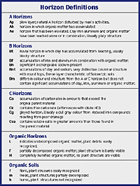
Soils develop over long periods of time, perhaps ten thousand years, as a response to the soil forming factors. With time, soils generally become deeper and develop distinct layers or horizons. The soil profile in mineral soils has three horizon types, from the surface downwards called A, B and C. Horizons can usually be distinguished by color differences, but closer study also shows differences in chemical and physical properties. Individual horizons have defining characteristics designated by a subscript such as Ah, Bt or Cca. The soil profile below is typical of a Dark Brown Chernozemic soil formed under native grassland. | |||
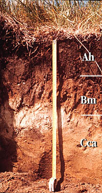
A horizon - is the top layer of soil (topsoil). This thin layer (usually less than 20 centimeters) is the most fertile because of the organic matter which has accumulated. In this layer roots are very dense and exude nutrients which stimulate microorganisms which results in a high biological activity. The A horizon is also darkest colored layer that establishes the soil zone. Topsoil can be easily eroded by water and wind and it is in this layer that the most leaching occurs. Leaching moves small mineral particles and salts downwards giving rise to a process called "eluviation" More leaching commonly takes place in soils which are under a vegetative cover of trees, rather than grasses, since effective moisture levels are higher. Forested soils frequently show a lighter coloured A horizon, as organic matter and iron compounds are carried downward. Grassland soils are darker, with an accumulation of more organic matter. The Chernozemic A horizons are distinguished on the basis of cultivation (Ap), accumulated organic matter from plant growth giving a granular structure (Ah) Whereas Luvisolic and Podsolic soils have a distinguishing Ae horizon that shows losses of clay and iron compounds to leaching. B horizon - The soil under the top layer is called subsoil. It is usually lighter in colour because it does not contain as much humus, making it less fertile. This layer can vary in thickness from a few centimetres to a metre or more. The B horizon shows accumulations of mineral particles such as clay and salts due to leaching from the topsoil. This process is called "illuviation". The B horizon usually has a denser structure than the A horizon, making it more difficult for plants to extend their roots. B horizons are distinguished on the basis of colour, structure and the kind of material that has accumulated in by leaching the horizons above. A Bt horizon has blocky structure with an accumulation of clay. A Bnt horizon accumulates both clay and sodium and has an easy to recognize columnar structure. The reddish Bf horizon has a significant accumulation of iron and aluminum. Whereas, the only differences in a Bm horizon are perhaps colour and structure. C horizon - lies under the subsoil and is called the "parent material". This is the original material from which the soil developed. This layer has large deposits of sand, gravel, pebbles, boulders and rock. The original parent material could be deposits from glacial activity, from sand and silt carried by the wind, from sediments carried by flowing water, including water in flood plains, or from gravity moving material down a slope. Another source of parent material is at the bottom of lakes. Aquatic plants die, and sink to the lake floor, then decay, forming a rich organic soil. The lake bed is also a collector of silt, clay and fine sand deposited by the processes of water and wind erosion. After a long period of time, the lake is filled with soil and a very fertile field is formed. This layer is relatively unaffected by actions in the other horizons, although some accumulations of calcium, magnesium and other salts can occur. Chernozemic C horizons usually have a parent material rich in calcium and magnesium carbonates designated Cca. C horizons that contain salts: sodium, magnesium, calcium sulphates and chlorides) are designated as Csa. Cg horizons are gleyed and show dull grey colours, sometimes with mottles - typical of poorly drained areas Bedrock - Under the layer of parent material is a layer of bedrock. In northern parts of Saskatchewan, bedrock is often visible at the ground level, but in southern Saskatchewan, with the exception of the Cypress Hills region, most bed rock is covered with tens of metres of glacial deposits.
|