

![]()
|
|
"Environmentally Sensitive Area". Please be careful where you walk and try not to disturb the natural environment. For additional information please contact Tourism Saskatchewan. | ||
| Second Meridian | |||
| GPS: | 50d 16.34m N | 102d 00.22m W | 1877 feet |
| Location: | 20 kms west of Whitewood on highway #1. | ||
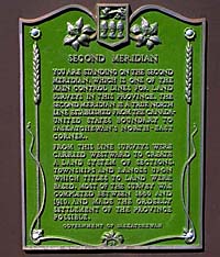
You are standing on the second meridian, which is one of the main control lines for land surveys in this province. The second meridian is a true north line established from the Canada - United States boundary to Saskatchewan's north-east corner. From this line surveys were carried westward to create a land system of sections, townships and ranges upon which titles to land were based. Most of the survey was completed between 1880 and 1910, and made the orderly settlement of the province possible. | |||