

|
|
"Environmentally Sensitive Area". Please be careful where you walk and try not to disturb the natural environment. For additional information please contact Tourism Saskatchewan. | ||
Cypress Hills Provincial Park | |||
| GPS: | 49d 35.58m N | 109d 55.26m W | 3948 feet |
| Location: | South-western Saskatchewan along the Alberta border. | ||
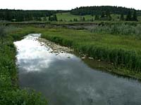
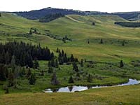
The Cypress Hills tower 600 metres above the surrounding landscape, and their flat-topped summits are covered with sweet-smelling lodgepole pine forests. They are the highest point of land between the Rocky Mountains and Labrador. Enter the Cypress Hills and take yourself into a world of high forested hills, panoramic views, quiet valleys and cool clean air. They are located in the "Horseshoe Region" of Saskatchewan and the Cypress Hills Interprovincial park covers 18,410 hectares. The park itself is a natural environment and has three campgrounds, each uniquely different than the others in setting and scenery. At 1,436m, the park has some of the highest hills east of the Rockies. Loch Leven is located in the centre of the campgrounds and cabin area, and is a quiet little waterway with a 5hp limit for all motorcraft using the water. The condition of the gap trail, which joins the east and west block of the park, is subject to the weather -- check before venturing by car across this cobble-stone trail. | |||
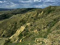
Million of years ago, a very large plateau existed in this area. Over thousands of years, most of the plateau eroded away, but the Cypress Hills plateau managed to escape this fate. When the climate became hotter and drier, the higher altitude of the hills provided cooler temperatures and higher rainfall, permitting the forest to flourish in a sea of open plains. | |||
The Cree called these hills 'myun-a-tuh-gow', or 'beautiful highlands' and the Crowfoot Indians called them 'ketwius netumoo' or 'hills that shouldn't be'. This beauty was discovered by French Canadian fur traders in the early 1800s. They are the ones who called these hills the Cypress Hills, mistakenly thinking the local lodgepole pine were Jack pine (Cypres in French). It is the perfect place to observe nature; over 200 species of birds can be seen including ones that normally occur only in northern forests or the Rockies. | |||
| GPS: 49d 35.58m N, 109d 55.26m W, 3948 feet 02 Aug 96, 2:45 pm, Fuji Velvia 50, F11 1/15s | |||
| GPS: 49d 38.79m N, 109d 50.88m W, 4444 feet 02 Aug 96, 12:30 pm, Fuji Velvia 50, F11 1/4s | |||