![]()
|
|
"Environmentally Sensitive Area". Please be careful where you walk and try not to disturb the natural environment. For additional information please contact Tourism Saskatchewan. | ||
| Trail Crossing | |||
| GPS: | 52d 55.35m N | 105d 48.33m W | 1400 feet |
| Location: | St. Louis. | ||

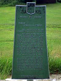
This site is close to the intersection of two early trails. One came from Fort A La Corne, crossed this coulee and ran to Batoche where it joined the Old Hunting Trail which followed the right bank of the South Saskatchewan River to the elbow. This route was probably first used by the founders of Fort A La Corne in 1753. After the Hudson's Bay Company built near the same site in 1850, it carried all the overland traffic between the Metis settlements on the south branch and that point. The other trail was a branch of the main Saskatchewan Trail which travelled the plains between Fort Garry and Edmonton. It left the main trail near Humboldt and ran north to Prince Albert. Between 1857 and 1895 it crossed the river here just below the hill at McKenzie's Crossing. | |||